by Prof. Theodoros Kariotis* The Greek-Turkish relations are arguably at their worst since 1974. It is, therefore, very important to understand this dangerous dispute and the importance of the United Nations Convention on the Law of the Sea (UNCLOS). In 1967, Malta’s ambassador to the United Nations, A. Pardo, called for the convening of an international conference to devise a new law of the seas. Fifteen years later, on December 10, 1982, nearly 120 countries signed the new UNCLOS.
Article 56 of UNCLOS provides the following rights of the coastal state in its economic zone:
- A. Exclusive sovereign rights for the purpose of exploring, conserving, and managing living and nonliving natural resources of the waters, the seabed, and subsoil
- B. Exclusive sovereign rights to control other activities such as the production of energy from the water, currents, and winds
- C. The right to control dumping of wastes
- D. The right to be informed of, participate in, and withhold consent for proposed marine scientific research projects
- E. The right to board, inspect, and arrest a merchant ship suspected of discharging pollutants in the economic zone.
Additionally, Articles 55 and 86 of the convention make it clear that the EEZ is neither a part of the territorial sea nor the high seas; it is a zone sui generis with a statute of its own.
The mistake of Turkey: Special Circumstances
At the end of 1986, Turkey unilaterally proclaimed a two hundred mile EEZ in the Black Sea. This move was in accordance with the provisions of UNCLOS, which Turkey has ironically never signed or ratified. Concurrently, Turkey reached an agreement on delimitation of the EEZ with the Soviet Union. This agreement used the equidistance method. There were no provisions of special circumstances or any reference to enclosed or semi-enclosed seas.
Thus Turkey, by accepting the concept of the EEZ as developed through UNCLOS, has weakened its position vis-à-vis Greece. This represents a fatal mistake for Turkey, a veritable Achilles heel in its dispute with Greece. Turkey’s attempt to implement a double standard position regarding the treatment of two semi-enclosed seas (Black and Aegean) is difficult to defend. It is simply an attempt to make a clear differentiation between delimitation of its maritime boundaries in the Black Sea and the Aegean Sea. A country cannot make a convincing argument by selectively choosing the parts of the convention it likes or dislikes.
For many years, Turkey has been adding issues at the negotiating
table, such as gray zones, demilitarization of islands, and the breadth
of the territorial waters.
"The common national position of the post-political period was, according to both Konstantinos Karamanlis and Andreas Papandreou, that Greece recognizes the existence of a dispute with Turkey, the delimitation of the continental shelf in the Aegean through an appeal to the International Court of Justice in The Hague. With the current data and more precisely we would say that Greece recognizes the existence of a difference with Turkey, the delimitation of the continental shelf and the Exclusive Economic Zone in the Aegean and the East. Mediterranean through an appeal to the International Court of Justice in The Hague. Appealing to international justice certainly makes sense only when the state seeking it is ready to accept the decision and demand its respect.”
A forgotten delimitation
There is a debate among experts and non-experts of UNCLOS about the
decision to take the Greek-Turkish dispute to the International Court of
Justice and each position cites previous decisions of the Court in
order to explain that their position is the correct one.
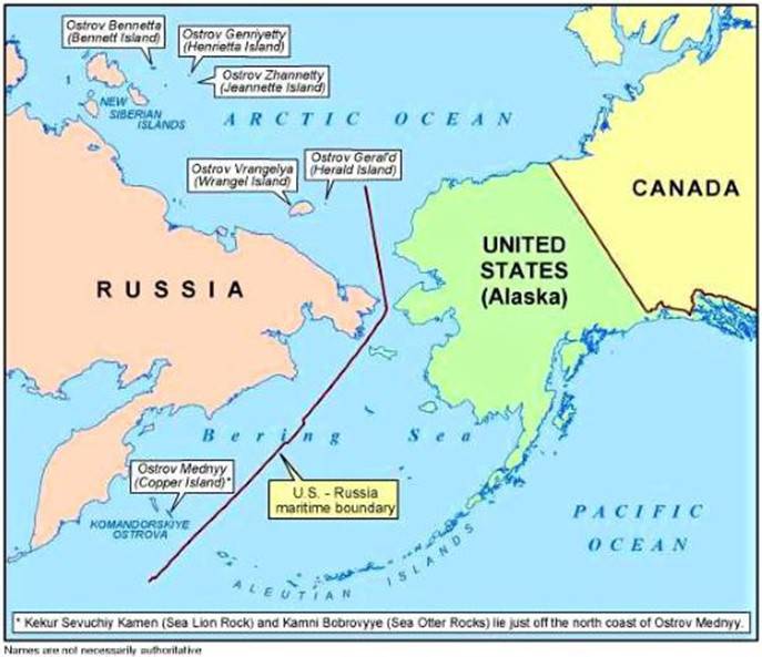
But all of them have forgotten the delimitation of EEZ between USA and USSR in the Alaska-Siberia region.
The delimitation between the United States and Russia was first agreed between the United States and the USSR on the 1st of June, 1990. Anyone looking at this map can clearly see that the American islands have received full effect and this is one of the reasons the United States has the second largest EEZ on our planet.
With its EEZ, Greece would safeguard the economic unity of its continental and archipelagic space. Greece has a total of 3,100 islands, of which 2,463 are in the Aegean. By comparison, Turkey has only three islands in the Aegean. A reason that most coastal states have unilaterally adopted the two hundred mile EEZ is to counteract overexploitation of their coastal fish stocks.
A large part of the Greek fishing fleet has traditionally operated in waters outside the Greek coasts, especially in the Mediterranean Sea and the Atlantic Ocean. Now that many states are establishing EEZs of their own, Greek fishermen have lost access to traditional fishing grounds. A Greek EEZ, therefore, would be beneficial to the fishing sector of the country, which, despite its small contribution (approximately 1 percent) to gross domestic product, has a substantial role in the nourishment of the Greek population by supplying protein of high nutritional value at a relatively low cost.
The Critical Issue of Delimitation
States seeking to delimit their maritime boundaries ought to consider certain facts and options as they develop their positions and resolve them through negotiations or third-party processes.
- It is clear that primary attention will be placed upon the geography of the coastline.
- The equidistant line will be considered in most circumstances as a basis for analyzing the boundary situation. It may very well be used in some form or variant to generate the boundary itself.
- A precise definition of the boundary line may be necessary at some point in the future. The boundary states would be well advised to memorialize their settlement in a technically precise form that would be unchallengeable in the future. The association of technical experts at the appropriate stages is strongly advised.
- The investment of substantial resources to study geological and geomorphological facts may be useful in either international litigation or negotiation. Knowledge of ongoing exploitation of living and nonliving resources by the boundary states in the boundary area is likely to be useful.
- Maritime boundary delimitations cannot be divorced from the status of the general relations between the boundary states. Actively hostile relations will doom boundary settlement negotiations and will make cooperative arrangements impossible to negotiate and implement.
- Joint development or management zones that cross boundaries, revenue sharing and management cooperation are all possible options. This last option, Greece should never negotiate with Turkey.
The Greek EEZ Delimitations
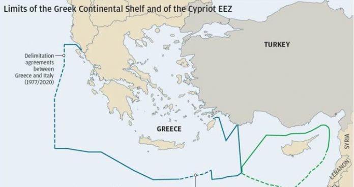
Greece has maritime borders with six countries: Albania, Italy, Libya, Egypt, Cyprus, and Turkey. It has, unfortunately, worked out delimitation details with only two of them. The first one was with Italy on June 8, 2020, and the boundary followed the existing delimitation of the continental shelf agreed in 1977. The delimitation was based on the median line and it very important to mention that all the islands on the Ionian Sea have been taken into account with this delimitation.
The second took place on August 6, 2020 between Greece and Egypt and it was a partial delimitation and its length was 104 n.m. and it did not follow the median line. Greece received 45% of the area and Egypt received 55%. It starts south of the island of Crete and extends up to the island of Rhodes, although the eastern part of the island is not included as the map below indicates.
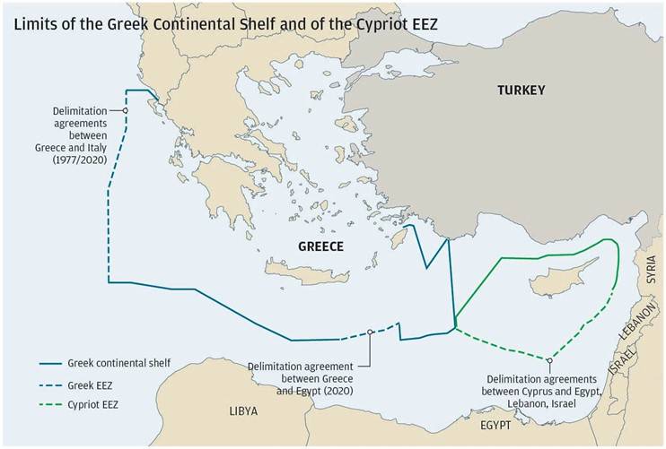
It was a mistake on the Greek side that the maritime areas southeast of Rhodes including those of Kastellorizo were left out of the delimitation process. If the agreement had applied to the whole maritime area between the two countries, the boundary would have been extended another 86 n.m. (total of 190 n.m.).
It is obvious that Egypt insisted on this partial delimitation because it wanted to show that it also had a maritime border with Turkey in the Eastern Mediterranean. Greece has four more delimitations to accomplish (Albania, Libya, Cyprus, and Turkey). But here lies an issue of shame for the Greek governments since 2004. The refusal of Greece to delimit its EEZ with that of Cyprus. From President Tassos Papadopoulos until today the Cypriots are asking for this delimitation and the Greeks continue to refuse. It has been called the "phobic syndrome”.
Costas Venizelos expressed the feelings of his Cypriot brethren when he wrote:
"It is clear that if Greece reaches a partial agreement with Egypt on
EEZs, it will mean that it is leaving Cyprus. This means that it is
abandoning the space that unites the two states. This is because it does
not want to provoke Turkey. It will be an act of self-immolation for
Hellenism, an action of adaptation to the demands of the occupying power
".

In recent years, especially after the discovery of hydrocarbons in the Eastern Mediterranean, and especially after the discovery of hydrocarbons in the Cyprus Exclusive Economic Zone (EEZ), Turkey has become more visible and expanded its ambitions by also dramatically increasing its activities in the Cyprus claiming for itself huge parts of the Cypriot EEZ.
From the time of Andreas Papandreou until today, no prime minister of Greece has included the EEZ as explicitly as the current Prime Minister Kyriakos Mitsotakis, when he declared: "Our only difference with Turkey is the delimitation of the EEZ and the continental shelf."
As Angelos Syrigos explained to "Sunday Kathimerini": "Turkey comes with a lot of issues. These include the claim on Greek islands, the Muslim minority in Thrace, the demilitarization of the eastern Aegean islands and primarily the joint exploitation of the wealth-producing sources of Greece and Cyprus with Turkey. In the Turkish perception, Greece and Cyprus are identical. Turkey is guided by the ideology of the "Blue Homeland", the main tool of which is the illegal Turkish-Libyan memorandum. The degree of its invocation by Ankara will determine whether dialogue (and any negotiations, if any) can have a future. There is an extremely small probability of this.. "
The history of 12 nautical miles
In addition to disputes among experts over the continental shelf, the EEZ and The Hague, we are witnessing a controversy over the expansion of the Greek territorial waters, which was supposed to have taken place after the signing of the 1982 UNCLOS in Montego Bay, Jamaica.
It has been 38 years since then, but the phobic syndrome has not left us, as Greece is the only coastal state on the planet that does not have a 12-nautical-mile territorial waters. Recently, a Presidential Decree on the closure of bays and the drawing of straight baselines in the Ionian Sea and Ionian Islands up to Cape Tenaro in the Peloponnese entered into force.
This Decree was created in order for Greece to extend its territorial waters from 6 n.m. to 12 n.m. only in the Ionian Sea. This partial extension violates UNCLOS and Greece is going to be ridiculed in the global community if we have six nautical miles in some areas, 8 n.m. in another one, and 12 n.m. in the Ionian Sea. It will be just as tragic and perhaps even more ridiculous to undertake (because this was also heard) a partial declaration of the EEZ and, even more ridiculous, a partial delimitation of the EEZ!
The size of our EEZ is the same either with territorial waters of six nautical miles, or of 12 n.m., as the increase in 12 nautical miles does not affect the size of the EEZ, because the EEZ has a length of 200 n.m. that, also contains the territorial waters. To be fair, it has been estimated that our EEZ, with a maritime zone of 6 nautical miles, encompasses 94.5% of the Aegean, while with 12 nautical miles it will own 95%!
The role of the Americans
The Americans believe that The Hague cannot resolve the Greek-Turkish dispute based on the precedent created by China's behavior. Since the 1960s, they have been promoting the idea of co-exploiting, or rather co-managing, the energy resources of the Eastern Mediterranean. The Americans, after World War II, knew the value of hydrocarbons and had begun secret search in the Eastern Mediterranean to locate the region's vast mineral wealth.
From 1922, the Turks considered that they had lengthy shores but did not have a large area of sea in the Eastern Mediterranean and after 1982 they realized that their sea was even more limited. Thus began a dangerous rhetorical war with two "hot” exceptions (1987 and 1996), but from 2018 they put forward further demands outside international law through their "Blue Homeland" doctrine, which will surely continue in the future.
Americans have known since the 1960s, when George Papandreou was prime minister of Greece, that the Turkish sea has no hydrocarbons. In 1984, a secret CIA report that analyzed all the issues of the Greek-Turkish dispute described a very important and critical finding on the issue of hydrocarbons in the Aegean: "There are no significant amounts of hydrocarbons in the Aegean Sea."
It is worth mentioning that the United States, which is only 90 miles
from the coast of Cuba, did not dare to claim that Cuba, because it is
an island, does not have full rights to its EEZ. It has delimited the
EEZ between the two states, using the method of "equidistance", that is,
the method the Turks hate so much. Finally, it is important to remember
that the United States did not use the Turkish argument that it has a
huge coastline in comparison to the Cuban coastline and therefore Cuba
should receive much smaller EEZ because it has a smaller coastline. When
the United States will have a new president after the 20th of January
2021, we are hoping and expecting that the United States will change its
policies towards Turkey, Greece, and Cyprus.
The Critical Issue of Delimitation
States seeking to delimit their maritime boundaries ought to consider certain facts and options as they develop their positions and resolve them through negotiations or third-party processes.
- It is clear that primary attention will be placed upon the geography of the coastline.
- The equidistant line will be considered in most circumstances as a basis for analyzing the boundary situation. It may very well be used in some form or variant to generate the boundary itself.
- A precise definition of the boundary line may be necessary at some point in the future. The boundary states would be well advised to memorialize their settlement in a technically precise form that would be unchallengeable in the future. The association of technical experts at the appropriate stages is strongly advised.
- The investment of substantial resources to study geological and geomorphological facts may be useful in either international litigation or negotiation. Knowledge of ongoing exploitation of living and nonliving resources by the boundary states in the boundary area is likely to be useful.
- Maritime boundary delimitations cannot be divorced from the status of the general relations between the boundary states. Actively hostile relations will doom boundary settlement negotiations and will make cooperative arrangements impossible to negotiate and implement.
- Joint development or management zones that cross boundaries, revenue sharing and management cooperation are all possible options. This last option, Greece should never negotiate with Turkey.
The Greek EEZ Delimitations
Greece has maritime borders with six countries: Albania, Italy, Libya, Egypt, Cyprus, and Turkey. It has, unfortunately, worked out delimitation details with only two of them. The first one was with Italy on June 8, 2020, and the boundary followed the existing delimitation of the continental shelf agreed in 1977. The delimitation was based on the median line and it very important to mention that all the islands on the Ionian Sea have been taken into account with this delimitation.
The second took place on August 6, 2020 between Greece and Egypt and it was a partial delimitation and its length was 104 n.m. and it did not follow the median line. Greece received 45% of the area and Egypt received 55%. It starts south of the island of Crete and extends up to the island of Rhodes, although the eastern part of the island is not included as the map below indicates.
It was a mistake on the Greek side that the maritime areas southeast of Rhodes including those of Kastellorizo were left out of the delimitation process. If the agreement had applied to the whole maritime area between the two countries, the boundary would have been extended another 86 n.m. (total of 190 n.m.).
It is obvious that Egypt insisted on this partial delimitation because it wanted to show that it also had a maritime border with Turkey in the Eastern Mediterranean. Greece has four more delimitations to accomplish (Albania, Libya, Cyprus, and Turkey). But here lies an issue of shame for the Greek governments since 2004. The refusal of Greece to delimit its EEZ with that of Cyprus. From President Tassos Papadopoulos until today the Cypriots are asking for this delimitation and the Greeks continue to refuse. It has been called the "phobic syndrome”.
Costas Venizelos expressed the feelings of his Cypriot brethren when he wrote:
"It is clear that if Greece reaches a partial agreement with Egypt on
EEZs, it will mean that it is leaving Cyprus. This means that it is
abandoning the space that unites the two states. This is because it does
not want to provoke Turkey. It will be an act of self-immolation for
Hellenism, an action of adaptation to the demands of the occupying power
".
In recent years, especially after the discovery of hydrocarbons in the Eastern Mediterranean, and especially after the discovery of hydrocarbons in the Cyprus Exclusive Economic Zone (EEZ), Turkey has become more visible and expanded its ambitions by also dramatically increasing its activities in the Cyprus claiming for itself huge parts of the Cypriot EEZ.
From the time of Andreas Papandreou until today, no prime minister of Greece has included the EEZ as explicitly as the current Prime Minister Kyriakos Mitsotakis, when he declared: "Our only difference with Turkey is the delimitation of the EEZ and the continental shelf."
As Angelos Syrigos explained to "Sunday Kathimerini": "Turkey comes with a lot of issues. These include the claim on Greek islands, the Muslim minority in Thrace, the demilitarization of the eastern Aegean islands and primarily the joint exploitation of the wealth-producing sources of Greece and Cyprus with Turkey. In the Turkish perception, Greece and Cyprus are identical. Turkey is guided by the ideology of the "Blue Homeland", the main tool of which is the illegal Turkish-Libyan memorandum. The degree of its invocation by Ankara will determine whether dialogue (and any negotiations, if any) can have a future. There is an extremely small probability of this.. "
The history of 12 nautical miles
In addition to disputes among experts over the continental shelf, the EEZ and The Hague, we are witnessing a controversy over the expansion of the Greek territorial waters, which was supposed to have taken place after the signing of the 1982 UNCLOS in Montego Bay, Jamaica.
It has been 38 years since then, but the phobic syndrome has not left us, as Greece is the only coastal state on the planet that does not have a 12-nautical-mile territorial waters. Recently, a Presidential Decree on the closure of bays and the drawing of straight baselines in the Ionian Sea and Ionian Islands up to Cape Tenaro in the Peloponnese entered into force.
This Decree was created in order for Greece to extend its territorial waters from 6 n.m. to 12 n.m. only in the Ionian Sea. This partial extension violates UNCLOS and Greece is going to be ridiculed in the global community if we have six nautical miles in some areas, 8 n.m. in another one, and 12 n.m. in the Ionian Sea. It will be just as tragic and perhaps even more ridiculous to undertake (because this was also heard) a partial declaration of the EEZ and, even more ridiculous, a partial delimitation of the EEZ!
The size of our EEZ is the same either with territorial waters of six nautical miles, or of 12 n.m., as the increase in 12 nautical miles does not affect the size of the EEZ, because the EEZ has a length of 200 n.m. that, also contains the territorial waters. To be fair, it has been estimated that our EEZ, with a maritime zone of 6 nautical miles, encompasses 94.5% of the Aegean, while with 12 nautical miles it will own 95%!
The role of the Americans
The Americans believe that The Hague cannot resolve the Greek-Turkish dispute based on the precedent created by China's behavior. Since the 1960s, they have been promoting the idea of co-exploiting, or rather co-managing, the energy resources of the Eastern Mediterranean. The Americans, after World War II, knew the value of hydrocarbons and had begun secret search in the Eastern Mediterranean to locate the region's vast mineral wealth.
From 1922, the Turks considered that they had lengthy shores but did not have a large area of sea in the Eastern Mediterranean and after 1982 they realized that their sea was even more limited. Thus began a dangerous rhetorical war with two "hot” exceptions (1987 and 1996), but from 2018 they put forward further demands outside international law through their "Blue Homeland" doctrine, which will surely continue in the future.
Americans have known since the 1960s, when George Papandreou was prime minister of Greece, that the Turkish sea has no hydrocarbons. In 1984, a secret CIA report that analyzed all the issues of the Greek-Turkish dispute described a very important and critical finding on the issue of hydrocarbons in the Aegean: "There are no significant amounts of hydrocarbons in the Aegean Sea."
It is worth mentioning that the United States, which is only 90 miles from the coast of Cuba, did not dare to claim that Cuba, because it is an island, does not have full rights to its EEZ. It has delimited the EEZ between the two states, using the method of "equidistance", that is, the method the Turks hate so much. Finally, it is important to remember that the United States did not use the Turkish argument that it has a huge coastline in comparison to the Cuban coastline and therefore Cuba should receive much smaller EEZ because it has a smaller coastline. When the United States will have a new president after the 20th of January 2021, we are hoping and expecting that the United States will change its policies towards Turkey, Greece, and Cyprus.
*
Theodoros Karyotis is an Emeritus Professor of Economics at the
University of Maryland. He was the first economic adviser to the
government at the Washington Embassy and was a member of the Greek
delegation to the UN Conference on the Law of the Sea during the tenure
of PM Andreas Papandreou.
(by slpress.gr, December 30, 2020)